Articles
The Cerro del Bu: an Islamic siege fortress at Tulaytula
Article author: Sergio Isabel Ludeña
Date of publication of the article: 26/07/2023
Year of publication: 2023
Article theme: 2023, Al-Andalus, Archaeology, Architecture, Patrimonio.
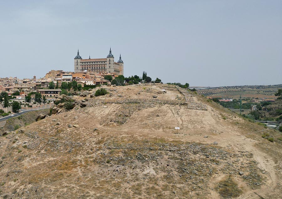
Cerro del Bu is an archaeological site located on a promontory opposite the historic centre of Toledo, on the opposite bank of the Tagus, next to the confluence created between the Degollada stream and the river. It was precisely in the highest part of this location – which has powerful natural defences on most of its sides and a strategic enclave – where an Islamic fortification was built, which different excavation campaigns have brought to light in recent decades. After an intervention promoted by the Consorcio de Toledo during 2014 and 2015, the space can now be visited and the signage makes it easier for anyone to approach both the prehistoric occupation – in which a Bronze Age settlement stands out – and the Andalusian remains.
The origin of the name
Although there has been some debate about the name of the hill, it seems that the toponym can be documented for several centuries. A document dated 1278 specifies the sale of a plot of land in the majuelo del Bum – which means owl in Arabic – in the pago de Val de la Degollada, which would indicate the origin of this curious name (Fernández del Cerro, 2014: 58).
The archaeological interventions (1904-2015): from the myth of the Stone Age castro to the reality as an Islamic fortification
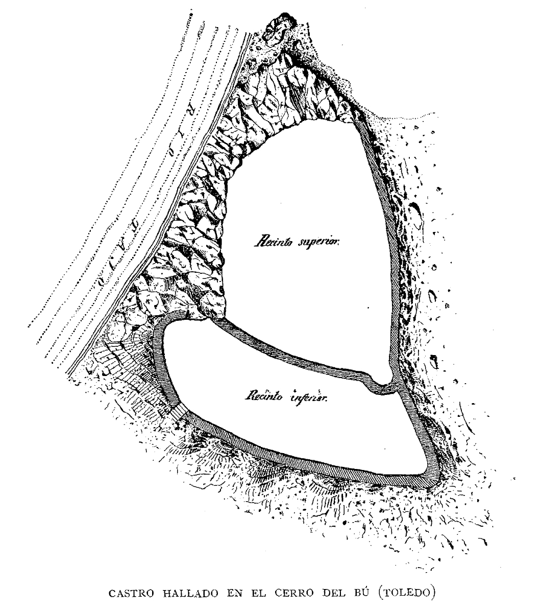
The earliest known archaeological work at Cerro del Bu dates back to 1904. The remains of the collapsed constructions were perceptible on the surface of the hill and attracted the attention of Manuel Castaños y Montijano, secretary of the Provincial Monuments Commission of Toledo, who was able to identify two fortified enclosures – currently visible after the excavation campaigns – but related them to a possible pre-Roman castro, as he published in the weekly El Castellano in 1904, although he still intended to confirm this assertion by carrying out an intervention.
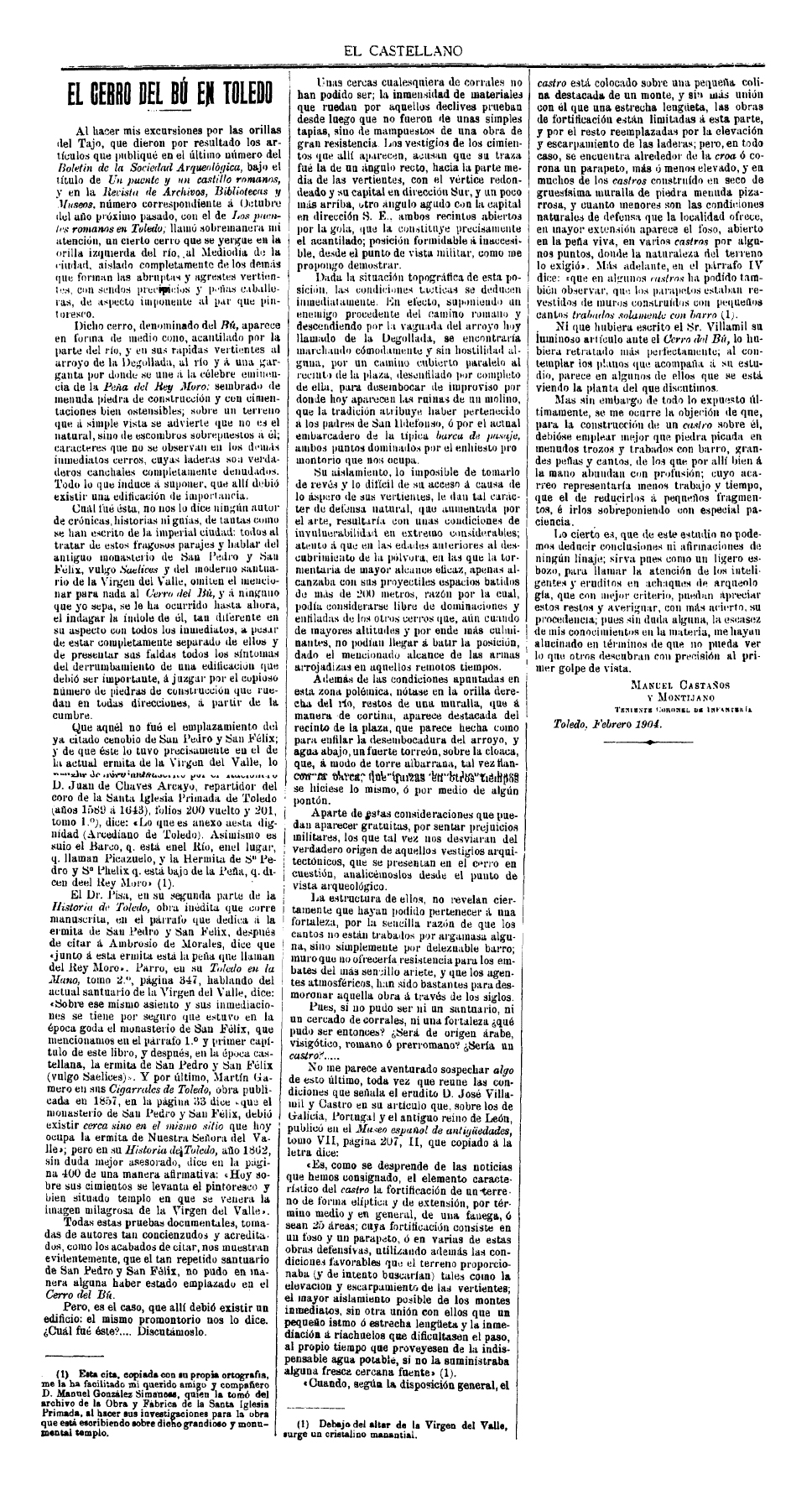
However, there was resistance from the owner of the land, the Count of Clavijo, to the development of archaeological excavations. In an attempt to obtain his permission to begin the work, the Provincial Monuments Commission sought the support of the Royal Academy of History. A set of documentation was sent to Madrid which, in addition to including the article by Manuel Castaños and a photograph of the site, included a selection of materials collected on the surface (half a stone disc, ceramic fragments and bone remains). The latter were studied by Juan Catalina y García, director of the National Archaeological Museum, and in an article published that same year in the Boletín de la Real Academia de la Historia he already indicated that: “(… ) the Cerro del Bu, due to its position away from any other dominant eminence, its conical shape with steep slopes, in some parts in an extraordinary way, and the two walls that trace a double enclosure on its upper part, was a fortified position, either to support the vigilance and hostility of an enemy besieging Toledo, placed there opposite and on the other side of the river, or to guard a road that passed from those fields to the south of the city to the same, using a bridge or a boat over the Tagus” (Catalina García, 1904: 440). Even before the archaeological excavations, Juan Catalina proposed a possible reading – correctly, as will be seen below – of both the historical – and not prehistoric – nature of the fortification and the fact that it had a siege objective over the city.
At the beginning of 1905, the owner finally gave his authorisation and the first campaign of archaeological excavations began under the direction of Manuel Castaños. After carrying out several trenches in both enclosures – upper and lower – his conclusions in the Boletín de la Real Academia de la Historia were the following: “(…) I have no hesitation in affirming, in a way that I consider indubitable, that the hill of Bu may have been the seat of a Castro or defensive refuge of the men of the Stone Age, and (…) of an existence well before the foundation of Toledo (…)” (Castaños y Montijano, 1905: 448). This interpretation by Manuel Castaños was maintained over time, so that the notion of Cerro del Bu as the “first Toledo”, the place of origin or primordial settlement of the city, gradually took shape in the imagination of the city’s inhabitants.
In the following decades, excavation campaigns were carried out in a sporadic and inconsistent manner. Until the 1950s we know of some, such as that of Aurelio Cabrera (1915), professor at the Toledo School of Arts, and that of the archaeologist Ismael del Pan (1928), which provided more information on the material culture of the enclave and a group of pieces were included in the collections of the provincial archaeological museum (Fernández del Cerro, 2014: 63). In contrast to these interventions, various sources report that the hill suffered an illegal plundering of materials. In the 1960s and 1970s, both Matilde Revuelta, director of the Museum of Santa Cruz, and Máximo Martín Aguado, Provincial Delegate of Excavations, demanded the declaration of the site to ensure its protection. In 1981 this was achieved and it was recognised as a National Monument (BOE no. 22; 26-1-81) and in 1992 it was declared an Asset of Cultural Interest by the Junta de Comunidades de Castilla-La Mancha (DOCM no. 37; 20-5-92).
The research situation changed drastically in the 1980s, when the Department of Prehistory and Ethnology of the University College of Toledo initiated a study project on the Bronze Age headed by Enrique de Álvaro Reguera and Juan Pereira Sieso. During eight archaeological excavation campaigns (between 1980 and 1988) the main objectives were to date the fortification – as noted, considered prehistoric at the time – and to delimit the Bronze Age occupation (Fernández del Cerro, 2014: 65). Although many of the published results are more focused on the prehistoric contexts[1], they also dealt with the Islamic fortress structures and the medieval levels of the site in their excavations. In fact, it was this intervention that finally made it possible to correctly establish the chronology of the fortified enclosures and their characteristics. Although we roughly agree with Manuel Castaños regarding the structure of the defensive spaces, the stratigraphic methodology used and the study of the materials found helped to confirm that the building has an Andalusian origin -in the 10th century, although with possible reoccupations in the 11th and 12th centuries- and a provisional character -in relation to a temporary camp enclosure to besiege Toledo- (Martínez Lillo, 1988). This puts an end – at least in the scientific sphere – to the image of Cerro del Bu as a Stone Age hillfort.
[1] For more information on them, see De Álvaro Reguera and Pereira Sieso, 1990 and Fernández del Cerro, 2014.
It was not until 2014 that archaeological work was carried out on the site again. Despite the interest of the findings of the campaigns of the 1980s, most of the remains of the hill were once again buried underground and could not be visited by the general public. This led the Consorcio de Toledo to promote a new campaign between November 2014 and October 2015, led by Juan Manuel Rojas Rodríguez-Malo. In this case, although some more areas were excavated -completing the data on the fortification-, the work mainly focused on the revaluation of the site. Thus, the remains of the fortress were finally left outside, consolidated and prepared for visits (Bonache Gutiérrez and Plaza Santiago, 2018) and the Consorcio de Toledo included the space in its programme of guided tours Rutas de Patrimonio Desconocido (Routes of Unknown Heritage).
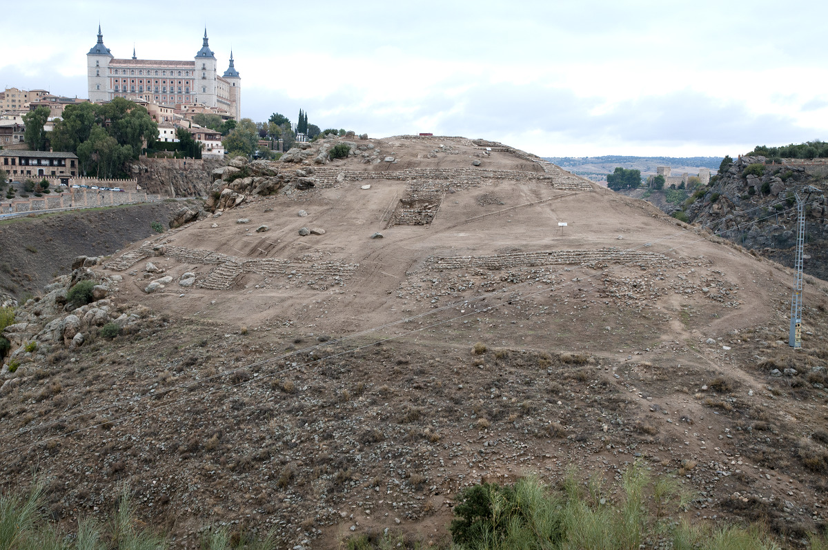
Unfortunately, in recent years the deterioration of the structures and the supporting elements for the visit has been increasing. The Cerro del Bu remains a crucial site for understanding the historical context of the city in the early Middle Ages. However, new action is once again necessary, especially to protect the remains and to renovate the elements of the site’s itinerary.
An Islamic hisn of the Toledo siege
The fortress, whose typology is generically known as hisn in Arabic, is characterised by two walled enclosures on two levels. The upper one is triangular in shape and occupies the highest part of the hill (about 700 m2 in area), while the lower one is trapezoidal (about 1,200 m2) and is located immediately below it. In the interior areas, especially on the upper terrace, remains of constructions have been found that have been interpreted as possible living areas (Rojas Rodríguez-Malo and Vicente Navarro, 2018: 147-163).
An analysis of how the fortress was built is essential in order to determine its nature and functions. The layout of the walls is completely adapted to the topography of the hill and no extensive levelling or foundation work was carried out. Archaeological excavations have also revealed that the walls were built with a base of mud-laid stones (the lowest and best preserved part of the construction) and the rest of the elevation was made of rammed earth (now completely lost). This confirms, on the one hand, the speed with which the hisn could have been built and, on the other, the provisional nature of the construction (Fernández del Cerro, 2014: 81).
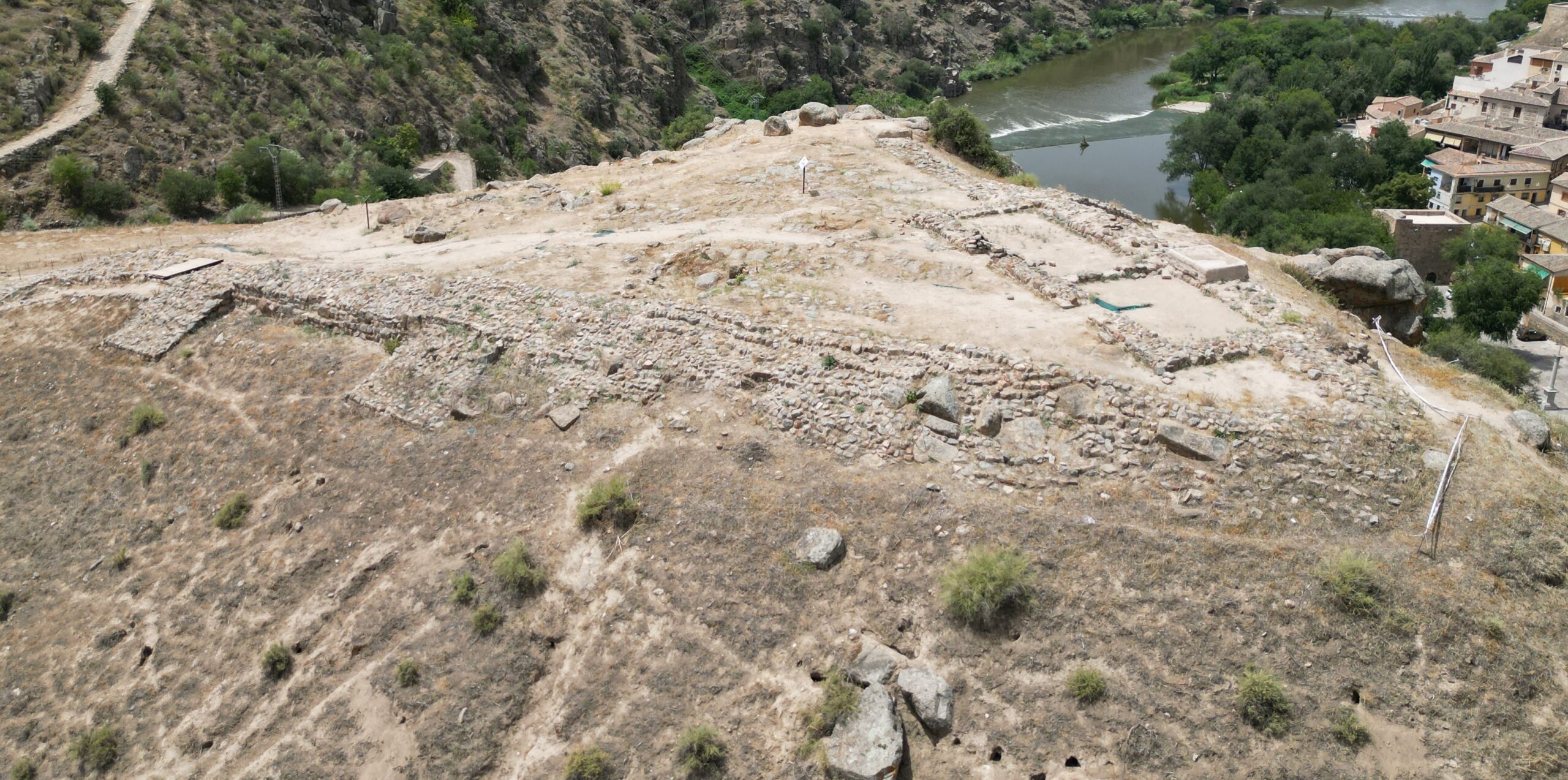
During the excavation campaigns, the collapse of the rammed earth walls was also documented. Due to the fact that these walls would have been mostly made of mud (earth mixed with other elements, heavily tamped and compacted by means of a formwork system), in order to protect them from deterioration they were treated and covered with a plaster rendering (Fernández del Cerro, 2014: 78-79) or lime mortar plastered with red paint (Rojas Rodríguez-Malo et al., 2019: 388).
Moreover, as a further indication of the temporary nature for which the construction was intended, its occupants had to add towers to the walls. They functioned not only as a military element, but mainly as stabilisation and support points for the structure -to compensate for the poor foundations- (Rojas Rodríguez-Malo et al., 2019: 386). In order to prevent the accumulation of water and damp, which was particularly dangerous for the rammed earth walls, water drainage channels were installed in the plinths of the building.
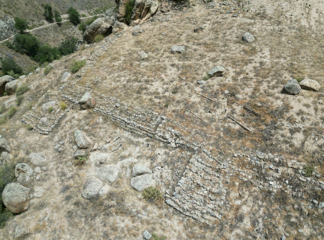
These characteristics of the fortification, together with the 10th century ceramic materials – typical of rather austere contexts (with hardly any glazed or luxury ceramics) – and the living areas, are what have led to the suggestion that it was a space used by a troop (Martínez Lillo, 1988: 108). According to researchers, the historical moment could fit in with the siege of Toledo between 930 and 932, at the beginning of the Caliphate of Córdoba, by Abd al-Rahman III. The location of the hisn on the other side of the river, opposite the city, in a space with powerful defences (natural and artificial) and the documentation on the decisions of the besieging army led by the caliph, who “to make it clear to those in the area that the siege would last as long as necessary, ordered the camp to be transformed into a group of buildings” (Lévi-Provençal, 1967: 276), have given strength to this hypothesis as the site of the siege of Toledo. If so, the Cerro del Bu would be the material testimony of the last uprising of a Tulaytula constantly rebelling against the Cordoban Umayyads.
Thanks to the support of archaeological research, the legendary image of the origin of Toledo in the supposed Stone Age castro is left behind and the historical reality of a siege hisn of Toledo is arrived at.
Bibliography
BOE n.º 22; 26-1-81
Bonache Gutiérrez, M. Á. y Plaza Santiago, R. (2018): «Restauración de paramentos en las excavaciones», en Sánchez-Chiquito de la Rosa (coord.), Cerro del Bú, de poblado de la Edad del Bronce a fortaleza andalusí. Los monográficos del Consorcio 6, Consorcio de Toledo, Toledo, 245-258.
Castaños y Montijano, M. (1905): «El Cerro del Bu y la Comisión de Monumentos de Toledo», Boletín de la Real Academia de la Historia, 46, 445-449.
Catalina García, J. (1904): «Exploraciones arqueológicas en el Cerro del Bu», Boletín de la Real Academia de la Historia, 45, 439-444.
De Álvaro Reguera, E. y Pereira Sieso, J. (1990): «El Cerro del Bu (Toledo)», Actas del Primer Congreso de Arqueología de la Provincia de Toledo, Diputación Provincial de Toledo, Toledo, 199-213.
DOCM n.º 37; 20-5-92
Fernández del Cerro, J. (2014): Aproximación al conocimiento de la Edad del Bronce en la Cuenca Media del Tajo. El Cerro del Bu (Toledo), Audema, Madrid.
Lévi-Provençal, 1967
Martínez Lillo, S. (1988): «El hábitat islámico del Cerro del Bu», I Congreso de Historia de Castilla-La Mancha, vol. V, 105-116.
Rojas Rodríguez-Malo et al., 2019: «La fortaleza de asedio andalusí en el Cerro del Bú de Toledo», Al-Kitab: Juan Zozaya Stabel-Hansen, 383-392.
Rojas Rodríguez-Malo, J. M. y Vicente Navarro, A. (2018): «Interpretación del yacimiento arqueológico», en Sánchez-Chiquito de la Rosa (coord.), Cerro del Bú, de poblado de la Edad del Bronce a fortaleza andalusí. Los monográficos del Consorcio 6, Consorcio de Toledo, Toledo, 215-243.


